Water Quality Management
Harmful Algal Bloom Detection & Monitoring from Space.
Blue-green algae outbreaks are increasing worldwide. Most organisations still rely on monthly sampling, finding out from complaints instead of data. There is a better way.
How it works
Every data source, one picture of your water body
Satellite coverage, weather feeds, and ground sensors get layered together. Each one fills gaps the others miss. The result: continuous bloom intelligence no single source could deliver alone.
Data sources
Optical satellite
Bloom extent, chlorophyll
Radar (SAR)
Sees through cloud cover
Buoys & sensors
Depth, nutrients, temperature
Drone imagery
High-res local detail
Weather feeds
Wind, temperature, rainfall
Your existing data
Lab results, sampling history
The difference at a glance
Case study
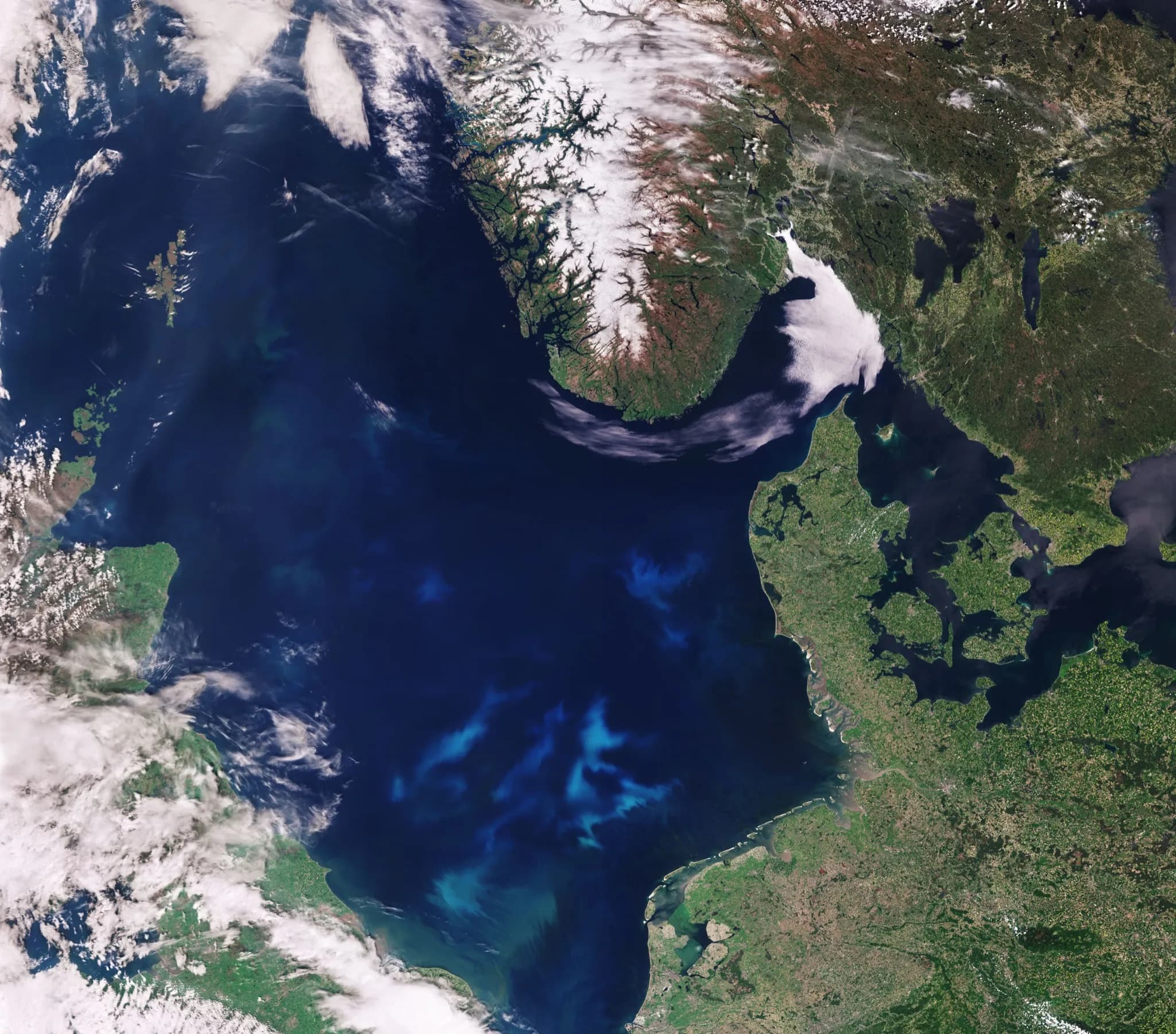
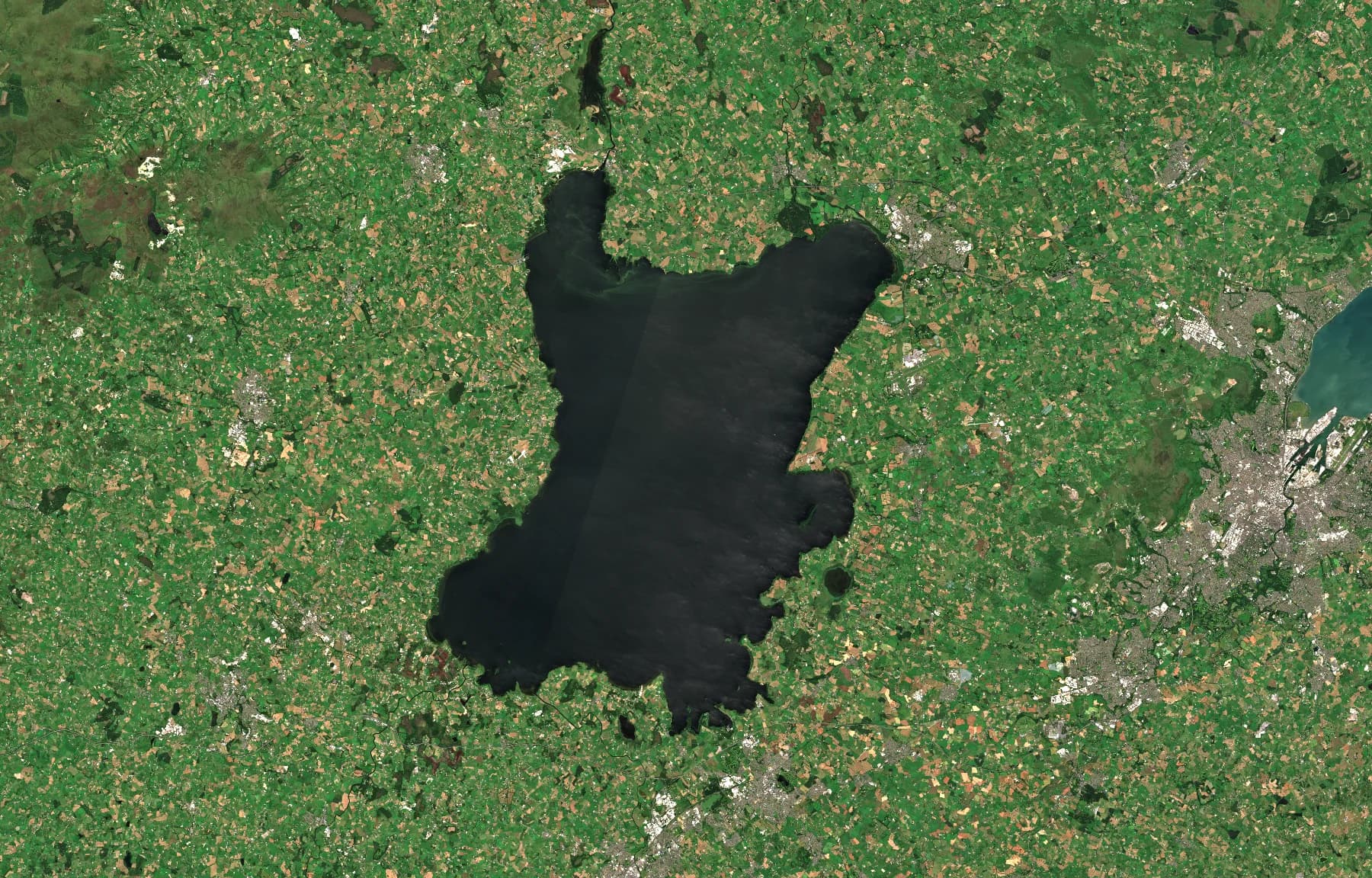
Lough Neagh: 383 km² of lake, monitored from orbit
Lough Neagh, the UK's largest freshwater lake, supplies 40% of Northern Ireland's drinking water. It is classified as hypereutrophic (high level of nutrients) and suffers from toxic blue-green algae blooms. Amelia's Planetary Intelligence Platform provides satellite data on algal bloom patterns that are difficult to track fully from the shoreline.
Three years of continuous monitoring using optical and SAR imagery, seeing through cloud cover.
Each validated against ground truth. The platform identified events before ground teams documented them.
Bloom movement, seasonal trends, and hotspot zones revealed from historical data.
Full lake coverage in every observation, with site selection intelligence for equipment deployment.
Seen from space
The same lake across 2025. Clear water in March, toxic bloom by August.
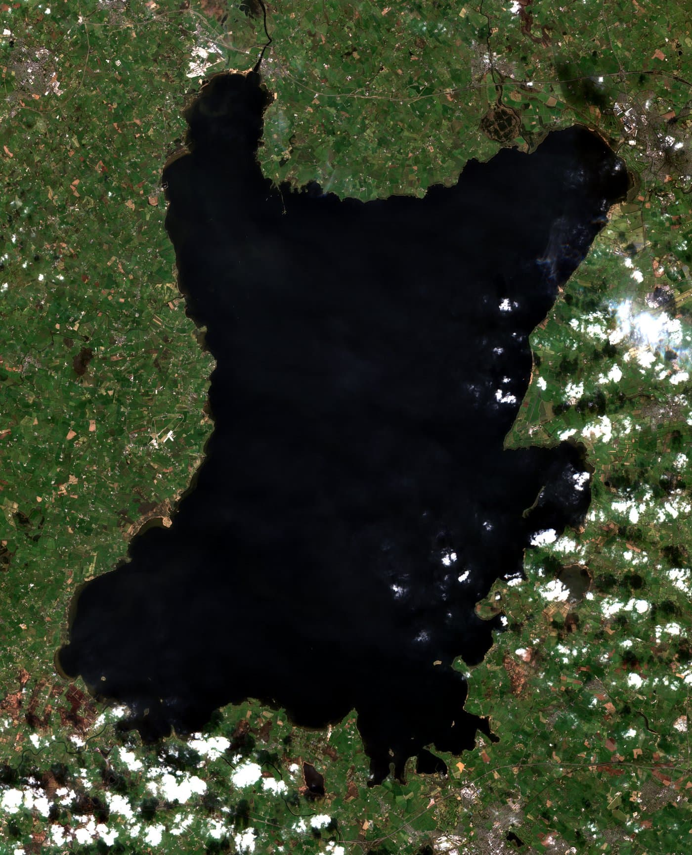
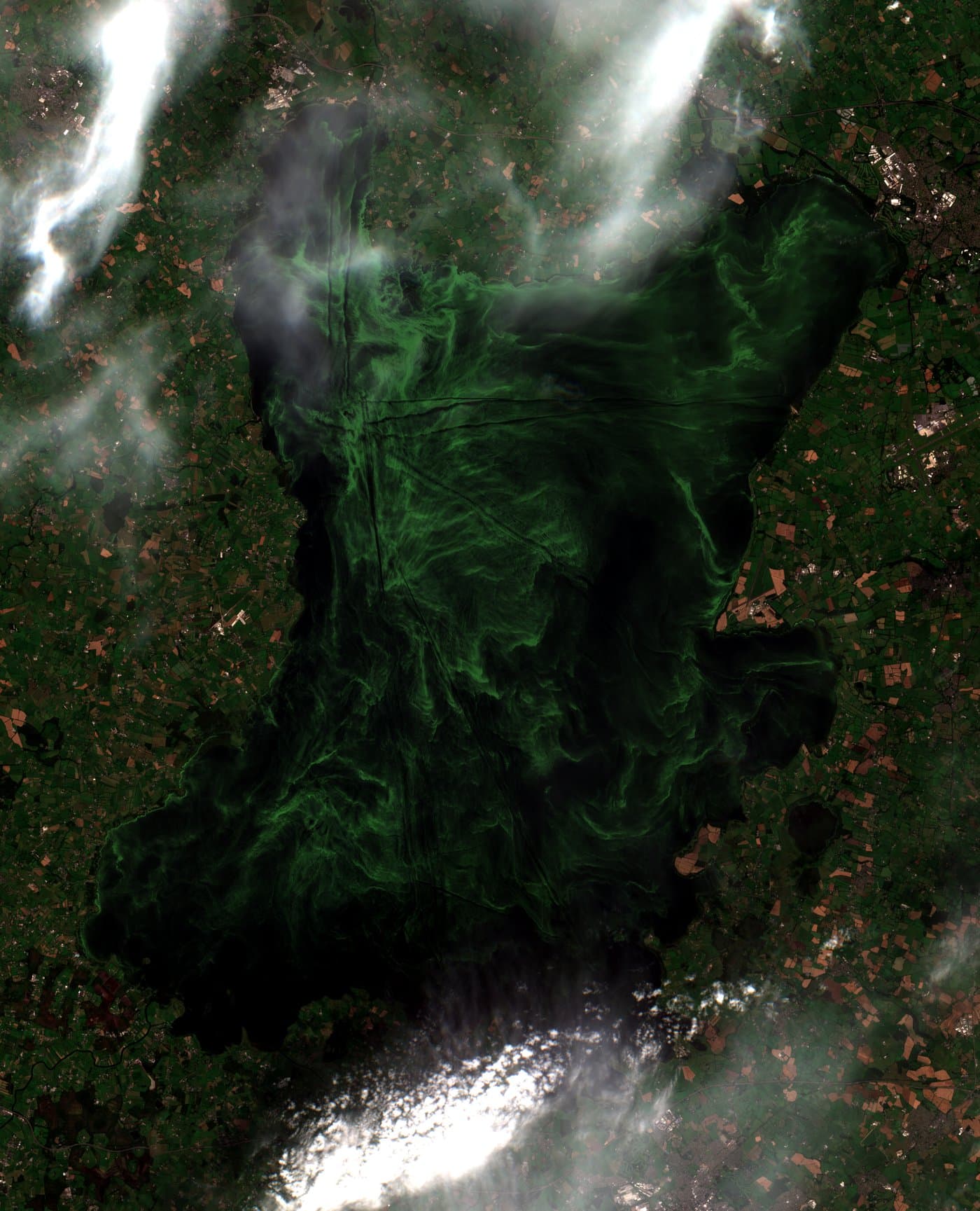
Sentinel-2 optical imagery, 10m resolution. Contains modified Copernicus Sentinel data.
Where blooms originate
All 7 events · 2023–2025 · first-detection coordinates in the central basin
All 7 bloom events tracked in this study have a first-detection coordinate from satellite: 5 from cloud-free Sentinel-2 chlorophyll detection and 2 from Sentinel-1 radar (which detects bloom-induced surface scum even through cloud). All 7 fall in the central basin (open water) of Lough Neagh, away from the shorelines and the major river inflows.
Sentinel-2 imagery, 10 m resolution. Contains modified Copernicus Sentinel data.
Amelia's Planetary Intelligence Platform in action
Watch how the platform tracks a bloom event across Lough Neagh
Bloom event tracking on Amelia's Planetary Intelligence Platform, showing particle transport analysis, satellite overlay timeline, and severity classification for Lough Neagh.
The pipeline
From satellite signal to decision
The Planetary Intelligence Platform processes data through four stages. Each stage adds intelligence. By the time it reaches you, it's not data anymore. It's a decision.
Detect
Satellite imagery monitors your entire water body every few days. When cloud cover blocks optical sensors, radar sees through. Ground data fills the gaps.
- Sentinel-1 & 2
- SAR + optical fusion
- Ground sensors
- Weather feeds
Understand
AI identifies bloom events, maps spatial extent, tracks movement, and correlates with environmental drivers like temperature, wind, and nutrients.
- ML classification
- Time-series analysis
- Ground truth validation
Predict
Risk models combine historical patterns with current conditions to forecast bloom probability before conditions escalate.
- Random Forest prediction
- Seasonal forecasting
- Trigger monitoring
Act
Intelligence becomes decisions: where to sample, where to deploy, who to alert, when to activate remediation.
- Automated alerts
- Hotspot prioritisation
- Partner coordination
Detection to remediation
Through integrated partnerships, intelligence connects directly to action. When the platform identifies where intervention is needed, remediation teams know exactly where to deploy.
Right now, somewhere in the world, a bloom is forming. Your water body could be next.
Who this is for
Wherever water quality matters
From drinking water supply to commercial operations, the platform adapts to how your organisation works with water.
Water utilities & reservoir managers
Algal contamination forces emergency treatment changes. You need early warning, not lab results that arrive too late.
Know about bloom conditions days before they affect intake. Plan treatment proactively. Protect supply continuity.
- ✓Full historical bloom analysis for your water body
- ✓Bloom detection, classification, and timeline
- ✓Risk alerts before conditions escalate
- ✓Validated against ground truth data
Lake & waterway managers
Public safety, compliance, and reputation depend on water quality you can only measure a few times a year.
Continuous visibility. Alerts when conditions change. An evidence base for decisions and funding requests.
- ✓Automated analysis on every satellite pass
- ✓Monthly trend reports and seasonal forecasts
- ✓Bloom risk alerts when conditions change
- ✓Evidence base for compliance and funding
Aquaculture & harvesting operations
You need to decide where to deploy equipment. Satellite data can answer the site selection question before you leave the office.
Know where the worst blooms are before you deploy. Cut scouting time. Arrive at the right site first.
- ✓Hotspot and site selection intelligence
- ✓Movement mapping and seasonal patterns
- ✓Environmental driver analysis
- ✓Visual report plus platform access
Government environment agencies
Responsible for water bodies across an entire region but only able to sample a fraction of them.
Evidence-based monitoring across your jurisdiction. Validated data for state of the environment reporting.
- ✓Multi-site monitoring across your jurisdiction
- ✓Integrate ground sensors, buoys, and IoT feeds
- ✓Validated data for state of the environment reporting
- ✓Root cause analysis and remediation coordination
Common questions
Optical satellites measure chlorophyll concentrations and water colour from orbit, while radar satellites detect surface roughness changes caused by bloom activity, even through cloud cover. Amelia's Planetary Intelligence Platform ingests imagery from multiple satellite programmes, including ESA Copernicus (Sentinel-1, Sentinel-2) and NASA missions (such as Landsat), then combines these signals with environmental data to identify, classify, and track bloom events across entire water bodies.
Frequency depends on latitude and the number of satellite passes that cover the water body. At mid-latitudes, radar imagery is typically acquired 4 to 5 times per week, and optical imagery every 2 to 3 days in cloud-free conditions. Combined, most freshwater lakes receive new satellite observations almost daily. When ground sensors or drone flights are connected, the picture updates even more frequently.
Satellite monitoring works for water bodies from approximately 0.5 km² upward. Larger water bodies benefit most because satellite coverage captures the full spatial extent in every observation, something that would require dozens of ground sampling points to achieve.
Optical satellites measure light reflected from the water surface, revealing chlorophyll concentrations and bloom extent, but they cannot see through clouds. Radar (SAR) satellites use signals that penetrate cloud cover, detecting surface roughness changes caused by bloom activity. Amelia's Planetary Intelligence Platform ingests both optical and radar imagery from ESA, NASA, and commercial providers, along with environmental data, to provide monitoring regardless of weather conditions.
Amelia's risk scoring models can identify conditions favourable for bloom development before a bloom becomes visible, by combining historical patterns with current environmental data such as temperature, wind, and rainfall. Once a bloom begins forming, the platform typically identifies it within one to two satellite passes, often days before it would reach levels that trigger complaints or affect water treatment.
Amelia's Planetary Intelligence Platform brings together satellite imagery, environmental data, and where available, ground observations into decision intelligence. It is designed to ingest data from multiple providers including ESA Copernicus and NASA programmes. For water quality, this means combining optical and radar satellite data with weather feeds and historical patterns to detect, track, and predict algal bloom events, providing continuous visibility instead of periodic sampling.